Geocodes | Yext Hitchhikers Platform
Overview
Geocodes are a set of latitude and longitude coordinates. When leveraging location data, coordinates are a more precise way to represent a physical location than just an address.
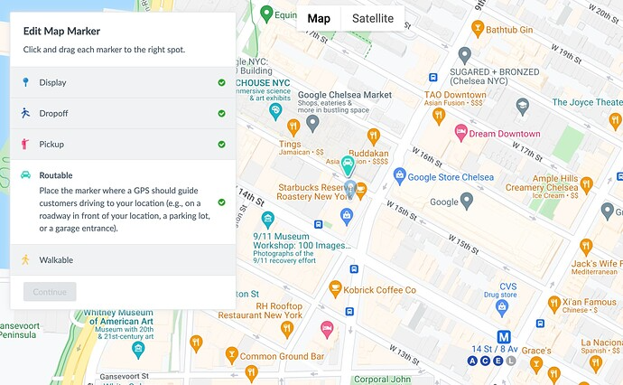
In Yext, you can store several different types of geocodes, including:
- Display: This should reflect the center point of your location.
- Dropoff: This lets you set where ride services or taxis should dropoff a visitor to your location.
- Pickup: This lets you set where ride services or taxis should pickup a visitor to your location.
- Routable: This lets you set where a GPS should guide a visitor with driving directions.
- City: This is automatically set based on your city/region to the center point of the city, and is best used for service area businesses.

Geocode Fields
Yext Content uses a variety of metrics to determine geocodes from addresses provided by Yext users.
In Content, the primary geocode fields are geocodedCoordinate, displayCoordinate, and yextDisplayCoordinate.
Each of these fields is populated either automatically or manually by the user. More information about each field is below:
| Field | Population | Description |
|---|---|---|
geocodedCoordinate |
Yext system | When the Address field is populated on an entity, Yext automatically geocodes the value and returns coordinates for the address. |
displayCoordinate |
User | User-provided coordinate values (via API, Connectors, or the Map Marker in Entity Edit). |
yextDisplayCoordinate |
Yext system | Yext selects the “best” geocode from the two fields above. This value is the most precise rooftop pinpoint for a location. |
Updating Geocodes
You can update any of the geocode types via the UI, by clicking into the map in Entity Edit and placing the pin for each type. You can also update geocodes by passing coordinate values via the Entities API or Connectors.
In most cases, when using Yext APIs to build out a map with a map marker, you’ll want to use the yextDisplayCoordinate value.

